LiDAR, an acronym for Light Detection and Ranging, is an advanced remote sensing technology that measures distance by emitting light beams, typically in the form of pulsed lasers, and calculating the time it takes for the light to reflect back from an object. Traveling at the speed of light (approximately 3×10^8 meters per second), this process allows for the precise determination of an object's position and distance based on the simple physical formula: Distance = Speed × Time. The unique capabilities of LiDAR technology have found applications across a wide range of industries and fields globally. From autonomous vehicles to environmental monitoring, from urban planning to archaeological exploration, LiDAR technology is revolutionizing how we observe and interact with the world. This article delves into 15 key applications of LiDAR technology, showcasing its transformative impact across various domains.

In the realm of autonomous driving, LiDAR technology plays a crucial role. It precisely maps the vehicle's surrounding s by emitting laser pulses and measuring the reflected light. This technology enables autonomous vehicles to detect and recognize other vehicles, pedestrians, obstacles, and road signs in real-time. The three-dimensional images provided by LiDAR help vehicles understand the complexity of their environment, facilitating quick and safe driving decisions. For instance, as an autonomous car navigates urban streets, LiDAR helps identify parked vehicles, predict pedestrian movements, and maintain efficient perception even in adverse weather conditions.
Related Blog:The Laser LIDAR Revolution: The Ascendancy of 1550nm Fiber Lasers

LiDAR significantly enhances the accuracy and efficiency of map-making in terrain mapping. Deployed from airplanes or satellites, LiDAR systems rapidly collect topographical data over large areas. This data is crucial for urban planning, flood risk assessment, and transportation infrastructure design. For example, when constructing new highways, LiDAR data can help engineers assess terrain obstacles for different routes, optimizing environmental impact and construction efficiency. Additionally, LiDAR can reveal hidden topographical features beneath vegetation cover, invaluable for archaeological and geological research.
Related Blog: Remote Sensing Mapping LIDAR Laser Source Solutions | Lumispot Tech
Related Products:1550nm Pulsed Erbium Fiber Laser

In forestry, LiDAR is used to measure tree height, density, and landform characteristics of forested areas, essential for forest management and conservation. For instance, analyzing LiDAR data allows forestry experts to assess forest biomass, monitor forest health, and even predict fire risks. In agriculture, LiDAR helps farmers monitor crop growth and soil moisture conditions, optimizing irrigation systems and enhancing crop yield.

LiDAR plays a significant role in environmental research and protection. It monitors and analyzes environmental changes, such as sea-level rise, glacier melting, and deforestation. For example, by analyzing years of LiDAR data, scientists can track the rate of glacier retreat and assess the impact of climate change on ecosystems. Additionally, LiDAR is used to monitor air quality in urban and agricultural areas, aiding in the formulation of more effective environmental policies.

In urban planning and management, LiDAR technology provides an effective tool for assessing city layouts and planning new infrastructure projects. Collecting high-resolution three-dimensional data, urban planners can better understand the spatial structure of cities, planning new residential areas, commercial centers, and public facilities. For instance, LiDAR data can help planners determine optimal public transportation routes, assess the impact of new construction projects on city skylines, and quickly evaluate infrastructure damage after disasters.

LiDAR technology in archaeology offers new possibilities for discovering and studying ancient civilizations. Capable of penetrating forest cover, LiDAR reveals ancient relics and structures hidden beneath dense vegetation. For example, in the tropical rainforests of Central America, LiDAR technology has helped archaeologists discover thousands of unknown Maya sites, significantly contributing to our understanding of ancient societal structures and cultures.

In natural disasters or emergency situations, LiDAR technology provides a rapid and effective response tool. For instance, following floods or earthquakes, LiDAR can be used to quickly assess the damage in affected areas, guiding rescue operations. Additionally, LiDAR monitors the impact of disasters on infrastructure, providing guidance for repair work.

In aviation, LiDAR is used for atmospheric research, measuring cloud thickness, air pollutants, and wind speeds. In space exploration, LiDAR technology is employed in probes and satellites to measure the topography of planets and celestial bodies. For example, LiDAR instruments in Mars exploration missions help scientists create detailed maps of the Martian surface, analyze its geological structure, and search for potential water sources.
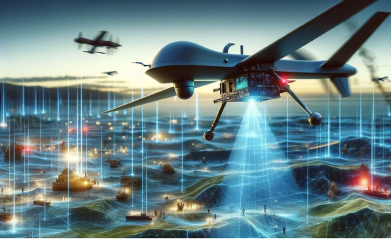
In military and defense, LiDAR technology is used for reconnaissance, target identification, and terrain analysis. It aids military personnel in navigating complex battlefield environments, identifying potential threats, and supporting tactical planning. For instance, LiDAR systems deployed on drones can conduct high-precision reconnaissance of enemy territories, providing critical intelligence information.
LiDAR technology in distributed temperature sensing systems is particularly important in large industrial facilities or energy transmission lines. LiDAR remotely monitors the temperature distribution of equipment or lines, identifying hotspots to prevent faults or fires. This is crucial for industrial safety and energy efficiency.
Related Blogs:Laser Application in Distributed Temperature Sensing (DTS)
Related Products:1550nm DTS LiDAR Laser Source
The diverse applications of LiDAR technology showcase its extensive impact in the field of modern technology. From autonomous vehicles to environmental monitoring, from urban planning to astronomical exploration, LiDAR technology is increasingly becoming a key tool for understanding and improving our world. As technology continues to advance, we can expect LiDAR to bring more innovations and breakthroughs in the future.
Bilik, I. (2023). Comparative Analysis of Radar and Lidar Technologies for Automotive Applications. IEEE Transactions on Intelligent Transportation Systems.
Gargoum, S., & El-Basyouny, K. (2017). Automated extraction of road features using LiDAR data: A review of LiDAR applications in transportation. IEEE International Conference on Transportation Information and Safety.
Gargoum, S., & El Basyouny, K. (2019). A literature synthesis of LiDAR applications in transportation: feature extraction and geometric assessments of highways. Journal of Transportation Engineering, Part A: Systems.
<p style="border: 0px solid rgb(217, 217, 227); box-sizing: border-box; --tw-border-spacing-x: 0; --tw-border-spacing-y: 0; --tw-translate-x: 0; --tw-translate-y: 0; --tw-rotate: 0; --tw-skew-x: 0; --tw-skew-y: 0; --tw-scale-x: 1; --tw-scale-y: 1; --tw-pan-x: ; --tw-pan-y: ; --tw-pinch-zoom: ; --tw-scroll-snap-strictness: proximity; --tw-gradient-from-position: ; --tw-gradient-via-position: ; --tw-gradient-to-position: ; --tw-ordina
Contact: Lumispot
Phone:
Tel: +86-510-87381808
Email: sales@lumispot.cn
Add: Bldg 4 No.99 Fu Rong 3rd Road, Wuxi, China

